Laxmi Basin Informal Lithounit I Fm
Type Locality and Naming
Type section (reference well) is in Site U1456, 0-120 mbsf. [Original Publication: D.K. Pandey, P.D. Clift, D.K. Kulhanek and the Expedition 355 Scientists. (2016). Proceedings of the International Ocean Discovery Program, Vol. 355. Publications.iodp.org]
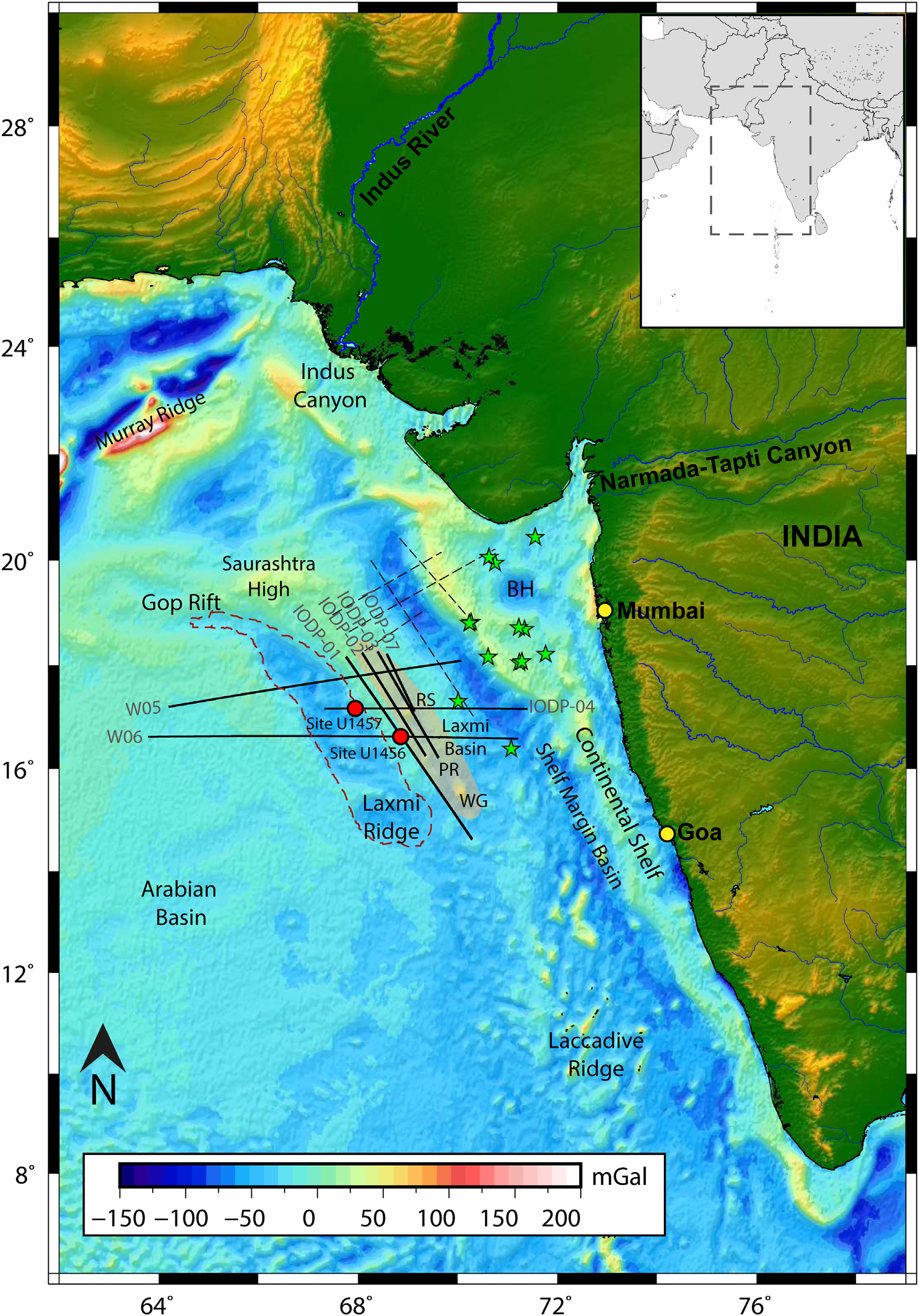
[Figure 1: Regional free air gravity anomaly map of the western Indian Ocean with mainland topography. The area of study is shown in the inset regional map. Superposed are the major tectonic elements (in black) and locations of seismic profiles (solid black lines) used for the present study. Drill locations of IODP Expedition 355 used to compare the litholog data with seismic sequences are marked in red circles. Green stars denote the location of the exploratory wells (NELP 2007) from the near shelf region. Demarcation of Laxmi Ridge from free air gravity anomaly response is denoted in red dashed lines. The interpretation from seismic profiles IODP-02, IODP-03, IODP-07, W05 and W06 are utilized as constraints for the present study and incorporated to generate the isopach map. The black dashed lines are the locations of published seismic profiles (Pandey et al., 2017; Nair and Pandey, 2018). The distribution of rivers in the Indian mainland is shown in blue. BH- Bombay High; RS- Raman Seamount; WG-Wadia Guyot, PR- Panikkar Ridge. The extent of PR modified from Pandey and Pandey (2015), (after Nisha Nair et al., 2021)]
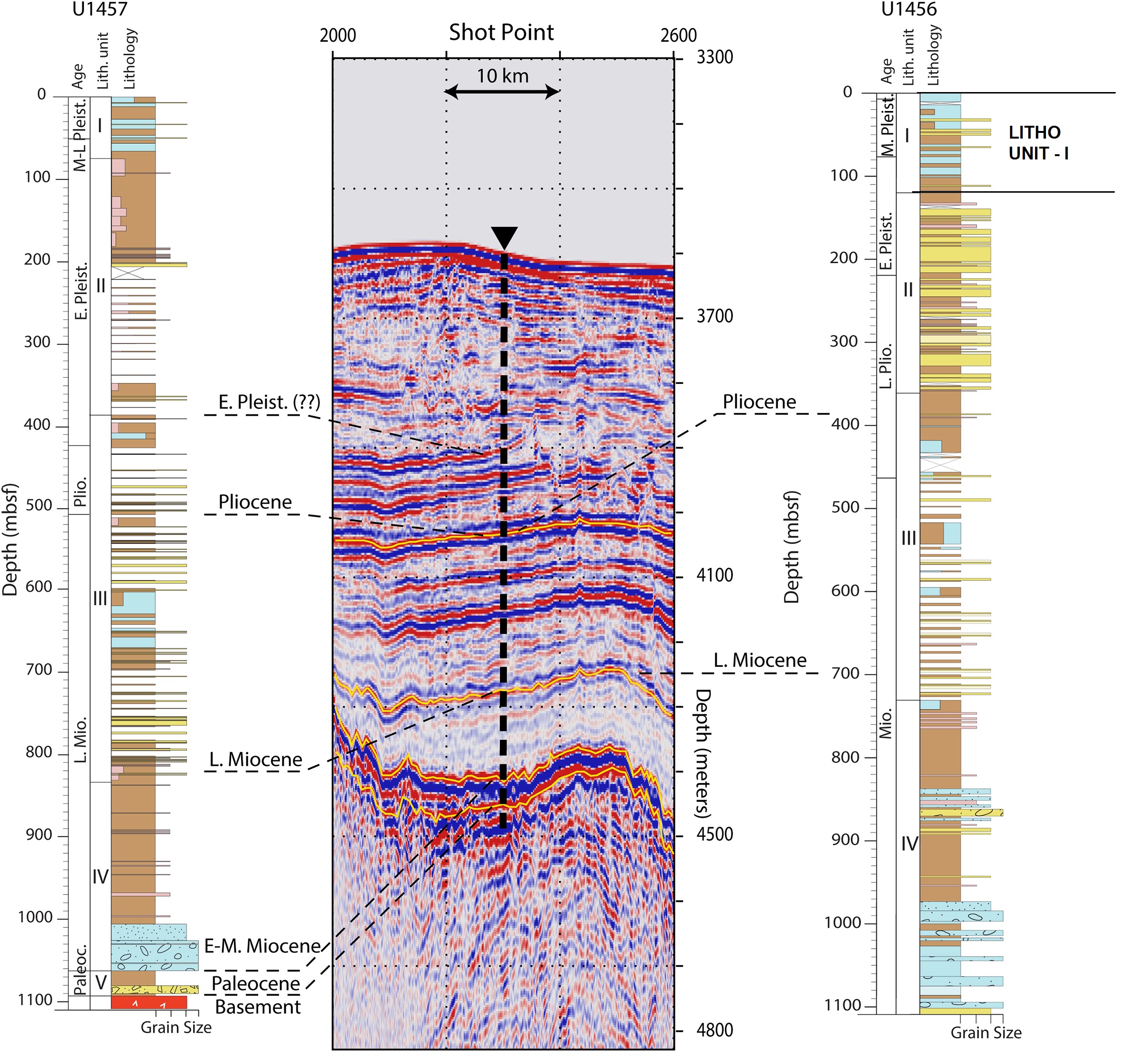
[Figure 2: Calibration of seismic horizons with sediments recovered from Sites U 1456 and U1457 (Pandey et al., 2016) in the Laxmi Basin. Seismic reflection profile IODP-04 crossing across drill site U 1457 shows the reflection configuration and correlated age from cores. Ages are assigned from the nannofossil biostratigraphic markers (IODP Expedition 355) using the geological time-scale (Gradstein et al., 2012), (after Nisha Nair et al., 2021)]
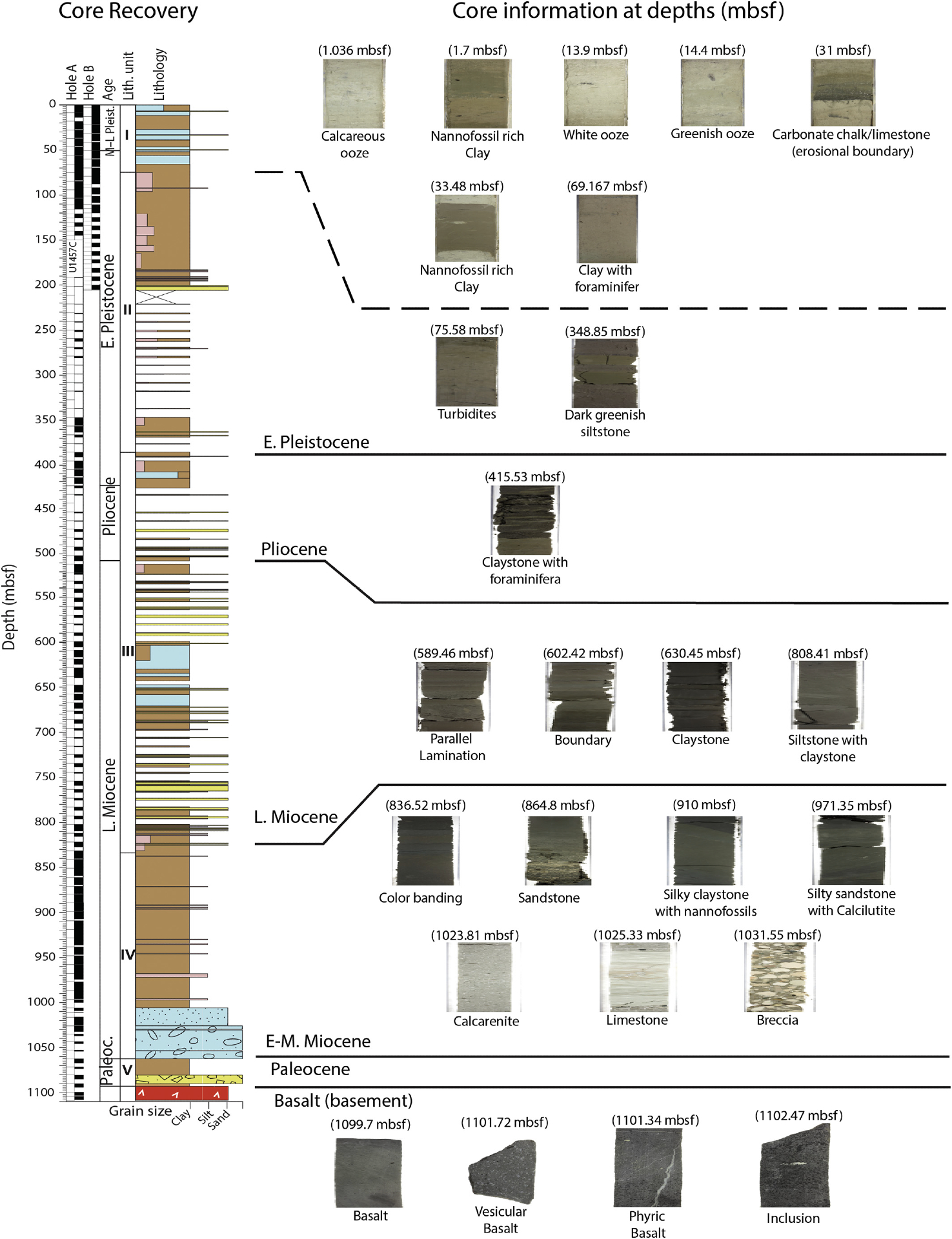
[Figure 3: Main sedimentary features corresponding to dominant lithology of each interpreted sequence from SiteU1457. The descriptions and depth of the cores are taken from the core log report of IODP Expedition 355, after Nisha Nair et al., 2021)]
Lithology and Thickness
Chalk to marl. Lithounit I is composed of light brown to light greenish nannofossil ooze or foraminifer rich nannofossil ooze interbedded with clay, silt and sand in addition to whitish calcareous ooze and nannofossil rich clay. Medium- to thick-bedded (<100 cm) nannofossil ooze layers are generally interbedded with thin and very thin silt and sandy silt beds that contain abundant foraminifers in the upper part of Unit I. In contrast, nannofossil ooze layers are rare in the lower part of this unit. The nannofossil ooze in Unit I is often very thick bedded (>100 cm), comprises >50% of the entire unit, and is sparsely interbedded with thin to very thin clayey silt and sandy silt layers. Its thickness is at Hole U1456A = 121.36 m, Hole U1456C = 121.30 m
Intervals – Hole U1456A = 0–121.36 mbsf, Hole U1456B = 0–29.03 mbsf (total depth), Hole U1456C = 0–121.30 mbsf
Relationships and Distribution
Lower contact
This unit boundary is distinguished by the abundance of calcareous and nannofossil ooze in Unit I versus the appearance of common sand and silty sand in Laxmi Basin Informal Lithounit II Fm.
Upper contact
Seawater
Regional extent
GeoJSON
Fossils
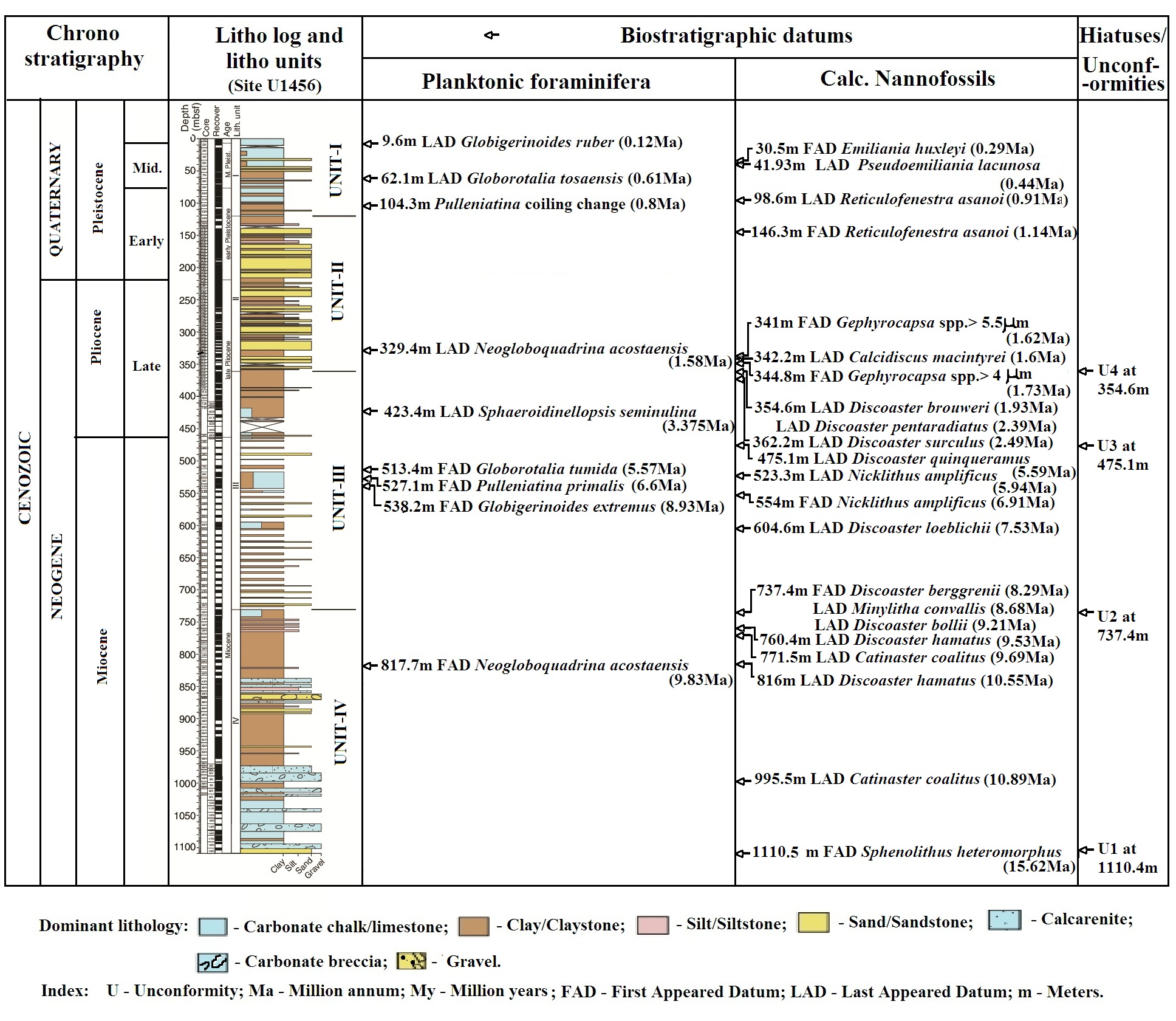
All the foraminiferal and calcareous datums given in table below:
[Figure 4: Biostratigraphic datums of Site U1456]
Age
Depositional setting
Additional Information
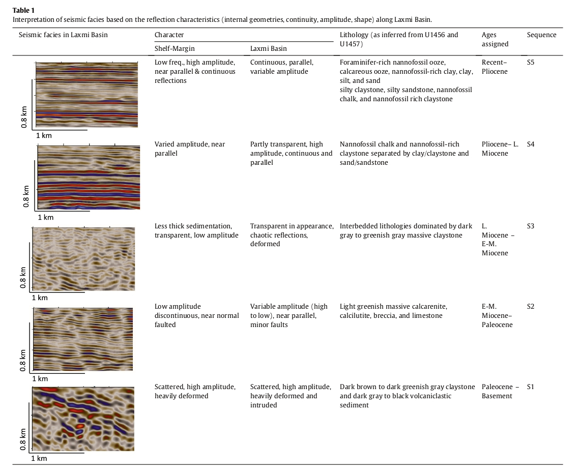
[Figure 5: Interpretation of seismic facies based on the reflection characteristics (internal geometries, continuity, amplitude, shape) along Laxmi Basin, (after Nisha Nair et al., 2021)]
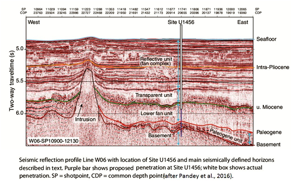
[Figure 6: Seismic reflection profile line W06 with location of Site U1456 and main seismically defined horizons described in text. Purple bar shows proposed penetration at Site U1456; white box shows actual penetration. SP = shotpoint, CDP = common depth point (after Pandey et al., 2016)]
